Typhoon Tapah forecast to bring heavy rain to southern South Korea

Seoul: The southern part of South Korea is expected to experience downpours and strong winds over the weekend as a small slow-moving typhoon is approaching from the south, the state-run weather agency said Friday.
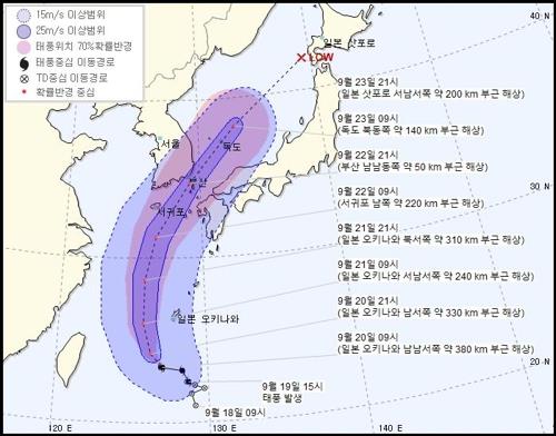
Typhoon Tapah, this year’s 17th, took shape 470 kilometers south of Japan’s Okinawa in the western Pacific Ocean the previous day and is currently tracking northward, the Korea Meteorological Administration said.
As of 3 a.m., the typhoon’s central pressure was 992 hectopascals and the maximum wind speed near its center was 20 meters per second, the agency said.
“The small typhoon was moving westward on seas 380 kilometers south-southwest of Okinawa at a speed of 24 kilometers per hour, ” the agency said, adding the typhoon is expected to gain force while it approaches the Korean Peninsula.
The typhoon is forecast to pass between the mainland and the country’s southernmost island of Jeju on Sunday morning, enter waters 170 km south-southwest of the southeastern port city of Tongyeong on Sunday afternoon and reach seas 30 km east-southeast of Dokdo in the East Sea on Monday morning, the agency said.
The typhoon is expected to bring up to 500 millimeters of rain to Jeju and 100-300 mm to South Gyeongsang and South Jeolla provinces as well as the large port city of Busan between Saturday and Monday.
YONHAP


